

Modern urban development would look very different today without the technological innovation that enabled the construction of skyscrapers. Symbolic of bustling city life, skyscrapers make up some of the world’s most recognisable city skylines. Many of them have become iconic landmarks in their own right.
This innovation began with the Bessemer Process in the 19th Century, which allowed for the mass production of steel. Then came the rolling mills metalworking technique. This allowed architects and engineers to design and build flexible frames that could be much taller than those used previously. Added to these were safety innovations, such as sprinkler systems. The later emergence of GPS and GNSS technology enabled ever more inventive and ambitious designs.
Growing Cities with Skyscrapers
Skyscrapers have since proved vital for the expansion and growth of cities. They allow more workers and residents to work and live in close proximity, within an infrastructure that provides all necessary utilities. City planners can now maximise space for both commercial and residential needs. Meanwhile, GPS/GNSS technology has revolutionised construction, meaning architects can produce ever more creative and sustainable designs.
The Skyscraper Revolution
The significance of skyscrapers in the revolution of urban landscapes is huge. They play a major role in both urbanisation and addressing population growth. Using relatively small footprints, they create vertical hubs of business and residential spaces. In short, skyscrapers allow cities to expand and meet the needs of growing populations, whilst minimising urban sprawl.
Of course, the construction of skyscrapers comes with many challenges. First and foremost, they must be structurally stable, safe and sustainable. The design and planning process itself also consists of many complex variables, including:
- Design of the foundations
- Vertical alignment of the building’s frame
- Placement of lift shafts
- Environmental factors
- Existing infrastructure
- Geography and geology
And many more.
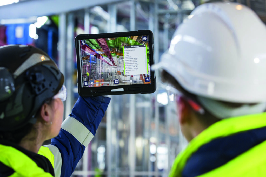
Today, architects can rely on advanced engineering techniques such as augmented reality (AR) and Building Information Modelling (BIM) to ensure the stability and safety of their designs. Meanwhile, geospatial technology, such as GPS/GNSS, provides real-time data updates. This means increased precision at every stage, from setting out to actual construction.
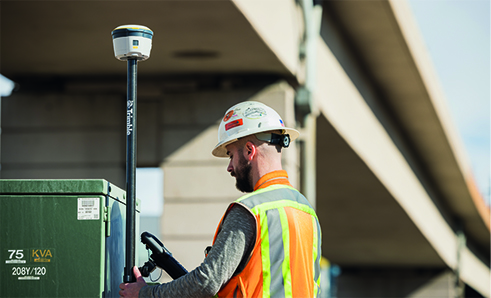
How Does GNSS Technology Work?
GNSS technology consists of two main components:
- Satellites orbiting the Earth which track the longitude, latitude and altitude of a device, and transmit positioning and timing data.
- GNSS signal receivers which interpret the signals and use the data to determine the location of a device.
The accuracy in positioning and the precision of GPS/GNSS technology is vital to skyscraper construction.
- accuracy in positioning refers to the radius of a circle of unknown around the true point. The smaller the radius, the higher the accuracy.
- precision represents the frequency at which a receiver can locate a point within that circle of accuracy, or if the circle is centred over the true point.
Global GNSS Technologies
There are four GNSS technologies currently providing global coverage:
- GPS – the most widely-known GNSS technology in the west, launched by the US government in 1978
- GLONASS – Russia’s GNSS technology, launched in 1982
- BeiDou – China’s version, launched in 2000
- Galileo – launched by the European Union in 2016 and currently used by the European Union Agency for the Space Programme
Other similar technologies exist but consist of fewer satellites and thus are only accurate within their own regions, such as India’s NavIC and Japan’s QZSS.
Skyscraper Foundations and Geodetic Control
One of the most vital aspects of laying skyscraper foundations is establishing an accurate geodetic control network. This network consists of stable and identifiable points with measured data that tie the points together.
These points can be measured very precisely and quickly using satellite geodesy, which makes it much more efficient than traditional terrestrial surveying. These accurate measurements allow for more precise machine control throughout the project, including during excavation phases, piling, compacting, drilling and bulldozing.
Eliminating Surveying Errors
Traditional surveying methods also have inherent disadvantages compared to GNSS technology. One such disadvantage is the accumulation of errors. GNSS technology eliminates this, maintaining reliable accuracy and precision throughout the planning and foundation-laying processes.
This reliability of accuracy provided by GNSS enables both a high-precision layout of skyscraper foundations and exact alignment in vertical construction. This latter aspect is crucial when it comes to the design and construction of elevator shafts and skyscraper cores.
Elevator Shafts, Verticality and GNSS
Accurate vertical alignment is necessary for the safe construction of skyscrapers, and GNSS technology is ideal for maintaining it. It is particularly important for the design and construction of elevator shafts and skyscraper cores. This is because the high precision ensures not only the stability of the structure but also the ongoing functionality of the inner workings of the building.
GNSS technology removes a lot of the human error which can contribute to construction problems. The data is not at the mercy of one individual’s competency and will remain accurate throughout the project by making any necessary corrections along the way.

Precise Crane Operations and Safety
One major construction safety concern involves the deployment of cranes. Precision crane operations are vital as the consequences of poor crane positioning can be catastrophic. It is therefore necessary to use the latest technological developments to ensure that all cranes are positioned safely and efficiently. Examples include:
- Load management – identifying when materials and equipment should be moved, and where they should be moved to.
- Risk identification – constantly changing environments, unstable terrain, personnel and the size and movement of cranes can all create potential risks.
- Cost management – getting cranes positioned incorrectly can delay a project, costing time and money.
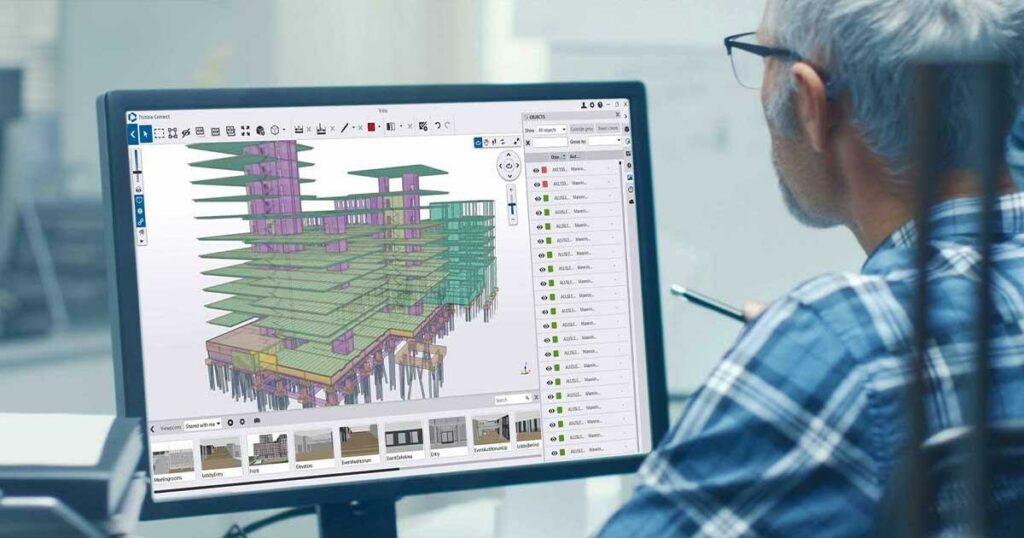
Building Information Modeling (BIM) Integration
BIM systems are first used in the planning of a construction project, and can be continually referred to until the project’s completion. BIM provides a digital representation of the project throughout its various stages, and enables collaboration between architects, engineers, contractors and local authorities.
GNSS technology integrates with a BIM system to ensure every aspect of the project is mapped out accurately. This greatly improves coordination and data sharing in skyscraper construction projects, helping keep the project on target for both time and cost.
Real-time data updates provided by GNSS integrated with BIM also provide multiple advantages for project management. They highlight design and construction problems early on while allowing clear and concise communication between all parties.
Sustainability and Efficient Urban Growth
As we become more aware of our responsibility towards the care of our shared planet, GNSS technology is contributing to sustainable skyscraper construction by minimising waste and optimising resources. Not only is this better for the environment, but it also provides a better ROI while helping complete the project as quickly as possible.
GNSS integrated with BIM analysis tools can significantly reduce a building’s carbon footprint by optimising energy efficiency. It helps reduce waste which further helps the environment, especially by ensuring there is minimal waste of building materials and other resources.
Today, construction methods are becoming much more precise and efficient thanks to GNSS, and all while lowering costs and saving resources.
Conclusion
Skyscrapers play a pivotal role in urban development and the efficient and sustainable growth of our cities. We must therefore use the best technology available to make the skyscraper construction process as precise and sustainable as possible.
GNSS technology is exactly what we need to build high-quality high-rise buildings that are safe and stable, while contributing to the urban beauty of our cities and skylines. Particularly when integrated with BIM, it provides all of the accuracy, reliability and safety that architects and construction workers need, as well as the many professionals and residents who will work and live in your finished project for years to come.